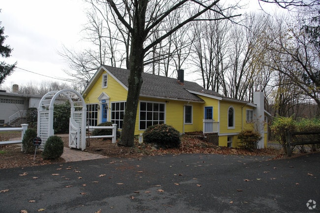
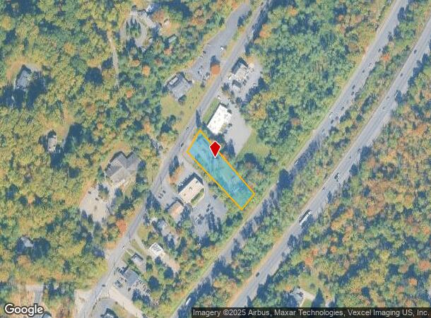
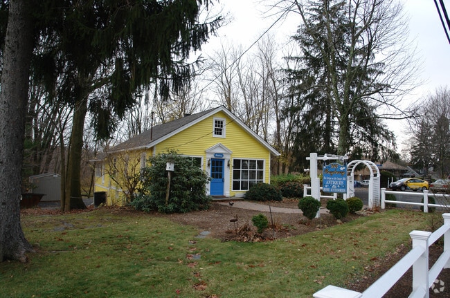
Property Record
912 Mount Kemble Ave, Morristown, NJ 07960
NEARBY LISTINGS FOR SALE OR LEASE
Property Detail
912 Mount Kemble Ave
Newark, NJ-PA
Morris
13-00035-01-00007
New Jersey
Retailwithmorethanonenonretailuse
7
2024
0.78 AC
2025
Morristown Region
044200
Northern New Jersey
1,488 SF
DEMOGRAPHICS near 912 Mount Kemble Ave
1 Mile
3 Mile
5 Mile
2024 Total Population
850
12,122
62,576
2029 Population
831
12,029
62,376
Pop Growth 2024-2029
(2.24%)
(0.77%)
(0.32%)
Average Age
46
43
42
2024 Total Households
309
4,378
23,826
HH Growth 2024-2029
(2.27%)
(0.85%)
(0.20%)
Median Household Inc
$177,941
$199,291
$161,089
Avg Household Size
2.70
2.70
2.50
2024 Avg HH Vehicles
2.00
2.00
2.00
Median Home Value
$1,071,667
$815,274
$750,993
Median Year Built
1963
1964
1967
Nearby Places
Map Layers
Map Styles
 Street
 Aerial
- Restaurants
- Banks
- Shops
- Fitness
- Groceries
PUBLIC TRANSPORTATION
COMMUTER RAIL
Bernardsville (Morris & Essex Gladstone Branch - NJ Transit Commuter Rail (NJ Transit))
DRIVE
WALK
Distance
Bernardsville (Morris & Essex Gladstone Branch - NJ Transit Commuter Rail (NJ Transit))
5 min
3.2 mi
Basking Ridge (Morris & Essex Gladstone Branch - NJ Transit Commuter Rail (NJ Transit))
DRIVE
WALK
Distance
Basking Ridge (Morris & Essex Gladstone Branch - NJ Transit Commuter Rail (NJ Transit))
6 min
3.4 mi
AIRPORT
Newark Liberty International
DRIVE
WALK
Distance
Newark Liberty International
35 min
26.2 mi
Freight Ports
Maher Terminal
DRIVE
WALK
Distance
Maher Terminal
38 min
26.7 mi
Nearby Properties
Address
Land Use
TOTAL SIZE
Lot Size
Zoning
Address
Land Use
TOTAL SIZE
Lot Size
Zoning
133.08 AC
E1
Address
Land Use
TOTAL SIZE
Lot Size
Zoning
13,428 SF
108.84 AC
OSGU
Address
Land Use
TOTAL SIZE
Lot Size
Zoning
396,029 SF
40.08 AC
OL40
Address
Land Use
TOTAL SIZE
Lot Size
Zoning
475,100 SF
38 AC
OL40
Address
Land Use
TOTAL SIZE
Lot Size
Zoning
17,112 SF
164.95 AC
OSGU
Address
Land Use
TOTAL SIZE
Lot Size
Zoning
110,101 SF
38.04 AC
OL40
Address
Land Use
TOTAL SIZE
Lot Size
Zoning
512.60 AC
PL
Address
Land Use
TOTAL SIZE
Lot Size
Zoning
7,872 SF
15.70 AC
Address
Land Use
TOTAL SIZE
Lot Size
Zoning
96,631 SF
13.69 AC
OB
Address
Land Use
TOTAL SIZE
Lot Size
Zoning
330.60 AC
PL
Address
Land Use
TOTAL SIZE
Lot Size
Zoning
8.67 AC
DCOR
Address
Land Use
TOTAL SIZE
Lot Size
Zoning
211,662 SF
33.83 AC
E5
Address
Land Use
TOTAL SIZE
Lot Size
Zoning
39.47 AC
PL
Address
Land Use
TOTAL SIZE
Lot Size
Zoning
100,860 SF
14.06 AC
OB
Address
Land Use
TOTAL SIZE
Lot Size
Zoning
277.10 AC
R-10
Address
Land Use
TOTAL SIZE
Lot Size
Zoning
2,381 SF
34.92 AC
E1
Address
Land Use
TOTAL SIZE
Lot Size
Zoning
2,976 SF
19.80 AC
SH2
Address
Land Use
TOTAL SIZE
Lot Size
Zoning
272.91 AC
PL
Address
Land Use
TOTAL SIZE
Lot Size
Zoning
16,496 SF
157.52 AC
R110
Address
Land Use
TOTAL SIZE
Lot Size
Zoning
26.04 AC
DCOR
Address
Land Use
TOTAL SIZE
Lot Size
Zoning
82,486 SF
43.40 AC
OSGU
Address
Land Use
TOTAL SIZE
Lot Size
Zoning
6,080 SF
100 AC
OSGU
Address
Land Use
TOTAL SIZE
Lot Size
Zoning
97.51 AC
PL
Address
Land Use
TOTAL SIZE
Lot Size
Zoning
190.60 AC
PL
Address
Land Use
TOTAL SIZE
Lot Size
Zoning
29,905 SF
7.47 AC
RR
Address
Land Use
TOTAL SIZE
Lot Size
Zoning
126 AC
R-10
Address
Land Use
TOTAL SIZE
Lot Size
Zoning
87.32 AC
RR
Address
Land Use
TOTAL SIZE
Lot Size
Zoning
34,806 SF
6.28 AC
SH1
Address
Land Use
TOTAL SIZE
Lot Size
Zoning
2,141 SF
111 AC
R1
Address
Land Use
TOTAL SIZE
Lot Size
Zoning
1,440 SF
125.03 AC
R-5
The World's #1 Commercial Real Estate Marketplace
Connect with us
© 2025 CoStar Group
The information above has been obtained from sources believed reliable. While we do not doubt its accuracy we have not verified it and make no guarantee, warranty or representation about it. It is your responsibility to independently confirm its accuracy and completeness. Any projections, opinions, assumptions, or estimates used are for example only and do not represent the current or future performance of the property. The value of this transaction to you depends on tax and other factors which should be evaluated by your tax, financial, and legal advisors. You and your advisors should conduct a careful, independent investigation of the property to determine to your satisfaction the suitability of the property for your needs.